


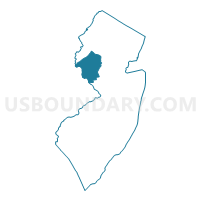
Hunterdon County PUMA, New Jersey
About
Outline

Summary
| Unique Area Identifier | 193376 |
| Name | Hunterdon County PUMA |
| State | New Jersey |
| Area (square miles) | 437.44 |
| Land Area (square miles) | 427.82 |
| Water Area (square miles) | 9.62 |
| % of Land Area | 97.80 |
| % of Water Area | 2.20 |
| Latitude of the Internal Point | 40.56528320 |
| Longtitude of the Internal Point | -74.91196950 |
Maps

Graphs
Select a template below for downloading or customizing gragh for Hunterdon County PUMA, New Jersey


Neighbors
Neighoring Public Use Microdata Area (by Name) Neighboring Public Use Microdata Area on the Map
- Bucks County (Central) PUMA, PA
- Bucks County (North) PUMA, PA
- Mercer County (North)--Princeton Borough PUMA, NJ
- Morris County (West) PUMA, NJ
- Somerset County (North & West) PUMA, NJ
- Somerset County (South) PUMA, NJ
- Warren County PUMA, NJ
Top 10 Neighboring County (by Population) Neighboring County on the Map
- Bucks County, PA (625,249)
- Morris County, NJ (492,276)
- Mercer County, NJ (366,513)
- Somerset County, NJ (323,444)
- Hunterdon County, NJ (128,349)
- Warren County, NJ (108,692)
Top 10 Neighboring County Subdivision (by Population) Neighboring County Subdivision on the Map
- Hillsborough township, Somerset County, NJ (38,303)
- Montgomery township, Somerset County, NJ (22,254)
- Raritan township, Hunterdon County, NJ (22,185)
- Washington township, Morris County, NJ (18,533)
- Hopewell township, Mercer County, NJ (17,304)
- Readington township, Hunterdon County, NJ (16,126)
- Branchburg township, Somerset County, NJ (14,459)
- Clinton township, Hunterdon County, NJ (13,478)
- Plumstead township, Bucks County, PA (12,442)
- Solebury township, Bucks County, PA (8,692)
Top 10 Neighboring Place (by Population) Neighboring Place on the Map
- Flemington borough, NJ (4,581)
- Lambertville city, NJ (3,906)
- High Bridge borough, NJ (3,648)
- Clinton town, NJ (2,719)
- New Hope borough, PA (2,528)
- White House Station CDP, NJ (2,089)
- Glen Gardner borough, NJ (1,704)
- Annandale CDP, NJ (1,695)
- Hampton borough, NJ (1,401)
- Frenchtown borough, NJ (1,373)
Top 10 Neighboring Elementary School District (by Population) Neighboring Elementary School District on the Map
- Flemington-Raritan Regional School District, NJ (26,766)
- Washington Township School District, NJ (18,533)
- Readington Township School District, NJ (16,126)
- Branchburg Township School District, NJ (14,459)
- Clinton Township School District, NJ (13,478)
- Chester Township School District, NJ (9,487)
- Bedminster Township School District, NJ (8,165)
- Mansfield Township School District, NJ (7,725)
- Washington Township School District, NJ (6,651)
- Lebanon Township School District, NJ (6,588)
Top 10 Neighboring Secondary School District (by Population) Neighboring Secondary School District on the Map
- Hunterdon Central Regional School District, NJ (51,468)
- North Hunterdon-Voorhees Regional School District, NJ (51,047)
- West Morris Regional School District, NJ (38,870)
- Warren Hills Regional School District, NJ (24,013)
- Delaware Valley Regional School District, NJ (16,680)
- South Hunterdon Regional School District, NJ (8,284)
Top 10 Neighboring Unified School District (by Population) Neighboring Unified School District on the Map
- Central Bucks School District, PA (114,377)
- Easton Area School District, PA (63,870)
- Hillsborough Township School District, NJ (38,721)
- Montgomery Township School District, NJ (22,936)
- Hopewell Valley Regional School District, NJ (21,811)
- Palisades School District, PA (14,936)
- New Hope-Solebury School District, PA (11,220)
Top 10 Neighboring State Legislative District Lower Chamber (by Population) Neighboring State Legislative District Lower Chamber on the Map
- General Assembly District 23, NJ (229,972)
- General Assembly District 16, NJ (215,874)
- General Assembly District 24, NJ (215,703)
- General Assembly District 15, NJ (204,558)
- State House District 29, PA (66,505)
- State House District 143, PA (62,909)
Top 10 Neighboring State Legislative District Upper Chamber (by Population) Neighboring State Legislative District Upper Chamber on the Map
- State Senate District 24, PA (278,648)
- State Senate District 10, PA (259,178)
- State Senate District 23, NJ (229,972)
- State Senate District 16, NJ (215,874)
- State Senate District 24, NJ (215,703)
- State Senate District 15, NJ (204,558)
Top 10 Neighboring 111th Congressional District (by Population) Neighboring 111th Congressional District on the Map
- Congressional District 12, NJ (701,881)
- Congressional District 11, NJ (674,349)
- Congressional District 7, NJ (672,885)
- Congressional District 8, PA (672,685)
- Congressional District 5, NJ (666,551)
Top 10 Neighboring Census Tract (by Population) Neighboring Census Tract on the Map
- Census Tract 459.02, Morris County, NJ (7,838)
- Census Tract 315, Warren County, NJ (7,725)
- Census Tract 102, Hunterdon County, NJ (7,664)
- Census Tract 113.02, Hunterdon County, NJ (7,263)
- Census Tract 112.01, Hunterdon County, NJ (7,235)
- Census Tract 110.02, Hunterdon County, NJ (7,135)
- Census Tract 38, Mercer County, NJ (6,746)
- Census Tract 319, Warren County, NJ (6,651)
- Census Tract 113.01, Hunterdon County, NJ (6,554)
- Census Tract 110.01, Hunterdon County, NJ (6,343)
Top 10 Neighboring 5-Digit ZIP Code Tabulation Area (by Population) Neighboring 5-Digit ZIP Code Tabulation Area on the Map
- 08844, NJ (38,367)
- 08822, NJ (30,354)
- 08865, NJ (29,840)
- 08876, NJ (22,179)
- 07882, NJ (14,492)
- 18938, PA (13,989)
- 07853, NJ (13,325)
- 08889, NJ (10,063)
- 08833, NJ (8,796)
- 07930, NJ (8,559)